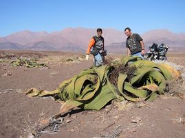
DOWN ARE EXAMPLE OF THE GREAT ESCAPEMENT IN OF NAMIBIA
Blog Archive
Sunday, 11 May 2014
THE GREAT ESCAPEMENT
The Great Escarpment swiftly rises to over 2,000 metres (6,562 ft). Average temperatures and temperature ranges increase as you move further inland from the cold Atlantic waters, while the lingering coastal fogs slowly diminish. Although the area is rocky with poorly developed soils, it is nonetheless significantly more productive than the Namib Desert. As summer winds are forced over the Escarpment, moisture is extracted as precipitation.The water, along with rapidly changing topography, is responsible for the creation of microhabitats which offer a wide range of organisms, many of them endemic. Vegetation along the escarpment varies in both form and density, with community structure ranging from dense woodlands to more shrubby areas with scattered trees. A number of Acacia species are found here, as well as grasses and other shrubby vegetation.
Sunday, 23 March 2014
Animals and Plants in the namib desert
Producers
|
Keystone species
A keystone species is a species which, while not necessarily the most abundant in an environment, plays a key role within the environment. In the Namib desert, the Camel Thorn tree fills one of the roles as a keystone species. Due to the lack of trees overall in this desert, the presence of these plants is beneficial to multiple organisms. Shade and shelter for animals is provided, as an escape from constant, intense sunlight. It is also available for bird nesting. However, a unique role that classifies this as a keystone species is the Camel Thorn's facilitation of seed dispersal. Plant life is not abundant in the desert biome, so any aid in the spread of seeds is beneficial.
Predator-Prey relationships
A predator-prey relationship in the Namib desert is exemplified between the black backed jackal and Cape fur seal pups by the coast. The jackals often travel in large groups while on hunting missions, making it nearly impossible for the pups to escape when unprotected, which they often are. Only the pup's mother is there to guard all of her offspring, resulting in an easier hunt for the group of predators. Because the black backed jackal has a strong reliance on readily available food sources, it is not limited by the pups as food, except partially in coastal packs. The pups are also limited by predators in the form of hyenas. Therefore, if the jackals were, for some reason, to stop hunting the pups, or if coastal jackal population decreased, the pups would most likely go through somewhat of a population increase.
Other than the seal pups, hyenas of the Namib desert also prey on the gemsbok. Particularly the brown hyena, which is more prominent in this area, is known for preying on this animal. Though the gemsbok is a fast creature, it also uses its large, curled horns to protect itself. This could be the reason that the calves, underdeveloped and less equipped, are more often chosen by the hyenas as prey, accounting for the gemsbok species' high mortality rate at a young age. This makes the gemsbok a Type III species.
Other than the seal pups, hyenas of the Namib desert also prey on the gemsbok. Particularly the brown hyena, which is more prominent in this area, is known for preying on this animal. Though the gemsbok is a fast creature, it also uses its large, curled horns to protect itself. This could be the reason that the calves, underdeveloped and less equipped, are more often chosen by the hyenas as prey, accounting for the gemsbok species' high mortality rate at a young age. This makes the gemsbok a Type III species.
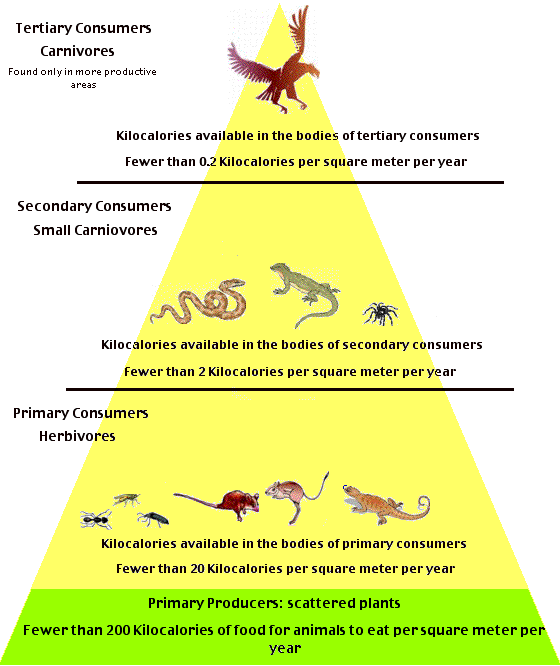
Trophic efficiency pyramid
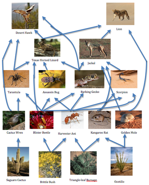
Food web
Role of predation
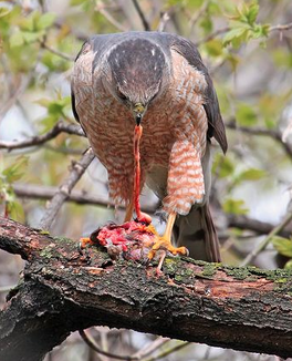
Population control is an attempt to limit the growth in numbers of a population. Many factors can affect and control population, but in the Namib Desert, predation plays a huge role. One example of this is seen in the jackal population. Jackals are carnivorous animals and they feed on many animals such as Barking Geckos, Golden Moles, Kangaroo Rats, and Scorpion. This single predator is also a huge food source for the Namib Desert Lion. If the population of the Jackal somehow decreases, and predation from this species decreases as a result, the original prey population will increase due to the lack of predation and organisms lower on the food chain such as certain types of plants will decrease. Another affect of the loss of this predator would lower the lion population drastically. The jackals provide a huge food source for the lions so the loss of this predator would take a great toll on the lion population. We see another example of population control through predation with the Desert Hawk. The Desert Hawk is one of the top predators in this ecosystem because it has no predators. It controls the population of many species including that of the Tarantula, Lizards, and Cactus Wren. By preying on certain animals, the Desert Hawk can keep the prey’s population down, in turn leading to a stable amount of primary producers or consumers that is preyed upon by the Hawk’s own prey. If the hawk population were to increase or decrease at any time, this balance would be broken and the population would not be controlled.
Tuesday, 18 March 2014
"Namib" redirects here. It is not to be confused with Namibia or Namibian (disambiguation).
| Namib Desert | |
| Desert | |
|
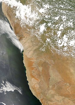
An image of the Namib Desert by the MODIS satellite
| |
| Countries | Namibia, Angola |
|---|---|
| Landmarks | Namib-Naukluft National Park,Naukluft Mountains,Skeleton Coast, Spitzkoppe,Sossusvlei, Deadvlei, Sperrgebiet |
| Rivers | Swakop River, Kuiseb River,Cunene River, Orange River,Olifants River, Tsauchab |
| Highest point | Brandberg Mountain 2,606 m (8,550 ft) |
| - location | Erongo, Namibia |
| - coordinates |  21°07′S 14°33′E 21°07′S 14°33′E |
| Lowest point | Atlantic Ocean 0 m (0 ft) |
| Length | 2,000 km (1,243 mi), N/S |
| Width | 200 km (124 mi), E/W |
| Area | 81,000 km2 (31,274 sq mi) |
| Biome | Desert |
The Namib is a coastal desert in southern Africa. The name Namib is of Nama origin and means "vast place". According to the broadest definition, the Namib stretches for more than 2,000 kilometres (1,200 mi) along the Atlantic coasts of Angola, Namibia, and South Africa, extending southward from the Carunjamba River in Angola, through Namibia and to the Olifants River in Western Cape, South Africa.[1][2]The Namib's northernmost portion, which extends 450 kilometres (280 mi) from the Angola-Namibia border, is known as Moçâmedes Desert, while its southern portion approaches the neighboring Kalahari Desert. From the Atlantic coast eastward, the Namib gradually ascends in elevation, reaching up to 200 kilometres (120 mi) inland to the foot of the Great Escarpment.[1] Annual precipitation ranges from 2 millimetres (0.079 in) in the most arid regions to 200 millimetres (7.9 in) at the escarpment, making the Namib the only true desert in southern Africa.[1][2][3] Having endured arid or semi-arid conditions for roughly 55–80 million years, the Namib may be the oldest desert in the world.[1][3]
Tuesday, 11 March 2014
LET US HAVE A LOOK ON THE NAMIBIA CENTRAL PLATEAU.
It run from south and its boarded by the skeleton coast to the north west.
The Namibia central plateau is home to the highest point in the country at KONIGESTEIN elevation 2,606 meters (8,550ft).
Within the wide flat central plateau is the majority of Namibia population and economy activity . Windhoek,the nation's capital city is located here.
here is the photo of Windhoek....the nation's capital city
It is were we can find most of the arable land
although arable land count for only 1 percent of Namibia , nearly half of the population is employed in agriculture.
th photo above r example of the arable land in Namibia.
The biotic condition here are similar to those found along the escapement ,however the topographic complexity is reduced summer temperature in the area can reach 40 degree Celsius (104) and frost common in winter.
TAKE A LOOK AT THIS PHOTO the photo show some of the central plateau part.
Saturday, 22 February 2014
WHAT IS GEOGRAPHY IN GENERAL?
IN GENERAL GEOGRAPHY IS THE STUDY OF EARTH`S LANDSCAPE .PEOPLE AND ENVIRONMENT . IT IS QUIET SIMPLY ABOUT THE WORLD IN WHICH WE LIVE.
IT SI UNIQUE I BINDING THE SOCIAL (HUMAN GEOGRAPYHY ) WITH THE NATURAL SCIENCE( PHYSICAL GEOGRAPHY ).HUMAN GEOGRAPHY CONCERNS THE UNDERSTANDING OF THE DYNAMIC OF CULTURES SOCIETIES AND ECONOMIES ,AND PHYSICAL GEOGRAPHY CONCERNS THE UNDERSTANDING OF THE DYNAMIC OF PHYSICAL LANDSCAPE AND THE ENVIRONMENT.
GEOGRAPHY PUT THIS UNDERSTANDING AND PHYSICAL OF SOCIAL AND PHYSICAL PROCESSES WITHIN THE CONTEXT OF PLACES AND REGIONS RECOGNIZING THE GREAT DIFFERENCE IN THE CULTURES ,POLITICAL ECONOMIES ,LANDSCAPE AND ENVIRONMENT ACROSS THE WORLD ,AND THE LINK BETWEEN THEM . UNDERSTANDING THE CAUSE OF DIFFERENCE AND INEQUALITIES BETWEEN PLACES AND SOCIAL GROUP UNDERLIE MUCH OF THE NEWER DEVELOPMENT IN HUMAN GEOGRAPHY
GEOGRAPHY PROVIDES AN IDEAL FRAME WORK FOR RELATING OTHER FIELDS OF KNOWLEDGE, IT IS NOT SURPRISING THAT THOSE TRAINED AS GEOGRAPHER OFTEN CONTRIBUTE SUBSTANTIALLY TO THE APPLIED MANAGEMENT OF RESOURCES AND ENVIRONMENT .
Subscribe to:
Comments (Atom)


.jpg)
